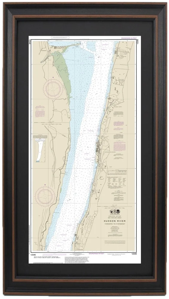
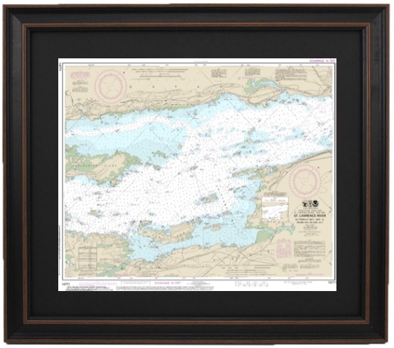
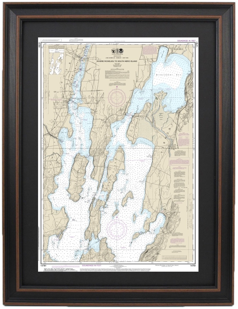
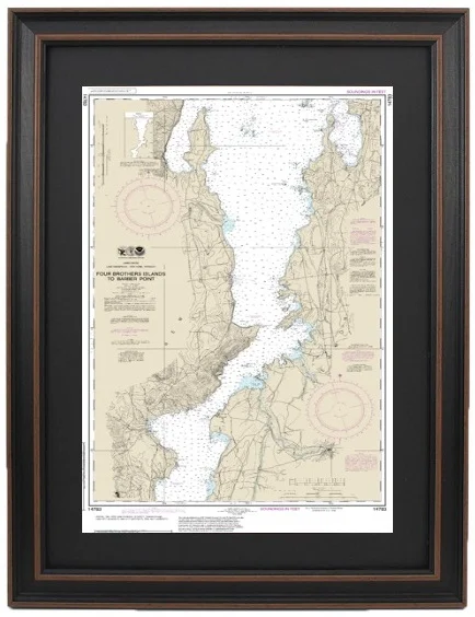
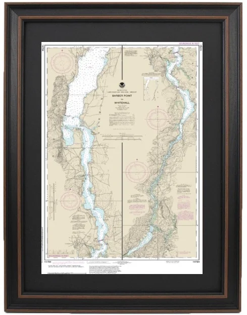
Framed Nautical Maps - New York Clear Filters Filter Clear Filter Framed Nautical Map 12300 - Approaches to New York from $149.99 Framed Nautical Map 12326 - Approaches to New York; Shinecock Light to Fire Island Light from $149.99 Framed Nautical Map 12327 - New York Harbor from $149.99 Framed Nautical Map 12331 - Raritan Bay from $149.99 Framed Nautical Map 12335 - Hudson and East Rivers; Lower Manhattan, NY from $149.99 Framed Nautical Map 12339 - East River, NY from $149.99 Framed Nautical Map 12341 - Hudson River; Days Point to George Washington Bridge from $149.99 Framed Nautical Map 12343 - Hudson River, NY to Wappinger Creek from $149.99 Framed Nautical Map 12345 - Hudson River, NY; George Washington Bridge to Yonkers from $149.99 Framed Nautical Map 12346 - Hudson River, NY; Yonkers to Piermont, NJ from $149.99 Framed Nautical Map 12347 - Hudson River; Wappinger Creek to Hudson, NY from $149.99 Framed Nautical Map 12348 - Hudson River; Coxsackie to Troy from $149.99 Framed Nautical Map 12350 - Jamaica Bay to Rockaway Inlet, NY from $149.99 Framed Nautical Map 12353 - Long Island, NY; Shinnecock Light to Fire Island Light from $149.99 Framed Nautical Map 12354 - Long Island Sound, NY; Eastern Part from $149.99 Framed Nautical Map 12358 - Long Island, NY; Shelter Island Sound and Peconic Bays from $149.99 Framed Nautical Map 12363 - Long Island Sound, NY; Western Part from $149.99 Framed Nautical Map 12402 - New York Lower Bay (Northern Part) from $149.99 Framed Nautical Map 13209 - Block Island Sound to Gardiner Bay from $149.99 Framed Nautical Map 13214 - Fishers Island Sound from $149.99 Framed Nautical Map 14500 - Great Lakes from $149.99 Framed Nautical Map 14772 - Ironsides Island, NY to Bingham Island, Ontario from $149.99 Framed Nautical Map 14773 - Gananoque, Ont to St. Lawrence Park, NY from $149.99 Framed Nautical Map 14774 - Round Island, NY and Gananoque, Ontario to Wolfe Island, Ontario from $149.99 Framed Nautical Map 14771 - St. Lawrence River; Butternut Bay, Ontario to Ironsides Island, New York from $149.99 Framed Nautical Map 14788 - Oneida Lake from $149.99 Framed Nautical Map 14781 - Lake Champlain; Riviere Richelieu to South Hero Island from $149.99 Framed Nautical Map 14791 - Cayuga and Seneca Lakes; Watkins Glen; Ithaca, NY from $149.99 Framed Nautical Map 14800 - Lake Ontario from $149.99 Framed Nautical Map 14802 - Lake Ontario, Clayton to False Ducks Island from $149.99 Framed Nautical Map 14803 - Lake Ontario, Six Miles South of Story Point to Port Bay; North Pond; Little Sodus Bay from $149.99 Framed Nautical Map 14806 - ThirtyMile PT, NY to Port Dalhouse, ONT from $149.99 Framed Nautical Map 14810 - Olcott Harbor to Toronto; Olcott and Wilson Harbors from $149.99 Framed Nautical Map 14811 - Chaumont, Henderson and Black River Bays, NY from $149.99 Framed Nautical Map 14813 - Oswego Harbor from $149.99 Framed Nautical Map 14815 - Rochester Harbor from $149.99 Framed Nautical Map 14816 - Lower Niagara River from $149.99 Framed Nautical Map 14822 - Niagara Falls, Lake Erie to Lake Ontario from $149.99 Framed Nautical Map 14823 - Lake Erie, Sturgeon Point to Twentymile Creek; Dunkirk Harbor; Barcelona Harbor from $149.99 Framed Nautical Map 14832 - Niagara Falls to Buffalo, NY from $149.99 Framed Nautical Map 12365 - South Shore of Long Island Sound Oyster and Huntington Bays from $149.99 Framed Nautical Map 14833 - Buffalo Harbor, NY from $149.99 Framed Nautical Map 14838 - Buffalo to Erie; Dunkirk; Barcelone Harbor from $149.99 Framed Nautical Map 14770- St. Lawrence River, Morristown, NY to Butternut, Ontario from $149.99 Framed Nautical Map 14782 - Lake Champlain, Cumberland Head to Four Brothers Island from $149.99 Framed Nautical Map 14783 - Lake Champlain, Four Brothers Islands to Barber Point from $149.99 Framed Nautical Map 14784- Lake Champlain, Barber Point to Whitehall from $149.99 Framed Nautical Map 14804 - Lake Ontario, Port Bay to Long Pond; Port Bay Harbor; Irondequoit Bay from $149.99 Framed Nautical Map 14805 - Lake Ontario, Long Pond to Thirtymile Point; Point Breeze Harbor from $149.99 Framed Nautical Map 14814 - Lake Ontario, Sodus Bay from $149.99 Framed Nautical Map 14772 - St. Lawrence River, Ironsides l., N.Y to Bingham I. Ontario from $149.99 No results found No results match your search. Try removing a few filters.